An ambitious ESA (European Space Agency) project to chart ten years in the life of the Earth's vegetation has reached a midway point, with participants and end-users having met to review progress so far. Harnessing many terabytes of satellite data, the GLOBCARBON project is intended to hone the accuracy of climate change forecasting. GLOBCARBON involves the development of a service to generate fully calibrated estimates of land products based on a variety of Earth Observation data, suitable for assimilation into sophisticated software simulations of the planet created by the global carbon modelling community.
The service is focused on the generation of various global estimates of aspects of terrestrial vegetation: the number, location and area of fire-affected land, known as Burnt Area Estimates (BAE), the area of green leaf exposed to incoming sunlight for photosynthesis, known as Leaf Area Index (LAI), the sunlight actually absorbed for photosynthesis, known as the Fraction of Absorbed Photosynthetically Active Radiation (fAPAR) and the Vegetation Growth Cycle (VGC).
The service is focused on the generation of various global estimates of aspects of terrestrial vegetation: the number, location and area of fire-affected land, known as Burnt Area Estimates (BAE), the area of green leaf exposed to incoming sunlight for photosynthesis, known as Leaf Area Index (LAI), the sunlight actually absorbed for photosynthesis, known as the Fraction of Absorbed Photosynthetically Active Radiation (fAPAR) and the Vegetation Growth Cycle (VGC).
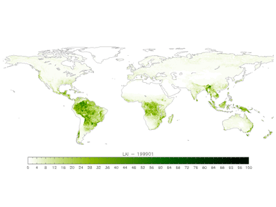
Worldwide leaf area index (LAI)
No comments:
Post a Comment